
These reports describe research in which IN-CORE platform tools have been used for research and analysis. Links to the full reports are provided.
UNDERSTANDING FLOOD SCENARIOS: A ROADMAP TO RESILIENCE, CHATHAM COUNTY, GA.
PR-2025-001-ChathamCounty
This study presents a comprehensive flood resilience analysis for Chatham County, Georgia, to inform policy decisions and guide resilience planning strategies. The analysis evaluates future flood hazard scenarios, identifying areas within the community vulnerable to current and mid

Municipalities within Chatham County
-century flooding. Considering the increasing frequency and intensity of precipitation, the study highlights evolving risks to help policymakers and stakeholders plan effectively for climate impacts. The overarching goal of this report is to support the County’s capacity to navigate urban growth and flood risk uncertainties, fostering a resilient and adaptive community.
The analysis was conducted using the IN-CORE platform (www.in-core.org), incorporating its Flood Damage Analysis model, Population Dislocation Model, and Computable General Equilibrium (CGE) model. To account for mid-century climate conditions, flood data from the Climate Risk and Resilience Portal (ClimRR) was integrated, providing a comprehensive assessment of climate projections and future risks.
Key Findings
Flood Risks
- Flooding in Chatham County is expected to get worse due to climate change, sea level rise, and heavier rainfall.
- Future scenarios include both coastal and inland flooding events that could affect large parts of the county, especially Tybee Island, Thunderbolt, and some areas of Savannah and unincorporated zones.
Building Damage
- 93% of buildings are unlikely to be seriously affected.
- About 6.5% may experience minor damage.
- Only a small number (around 230 buildings) are at high risk of major or total damage.
- Areas with the greatest risk include Tybee Island and Thunderbolt.
Displacement of Residents
- Floods could force over 7,000 households (about 6%) to leave their homes temporarily.
- Displacement affects lower-income and minority communities disproportionately.
Economic Impact
- Industries like retail, hospitality, and health services are vulnerable.
- In a severe flooding event:
- Property losses could exceed $3 billion.
- Middle- and high-income households could suffer significant income drops, especially those owning valuable properties.
- Job losses and lower productivity will impact the local economy.
Planning and Existing Efforts
Chatham County has already taken several steps, including:
- Creating floodplain management plans.
- Studying repetitive flood losses and sea level rise.
- Upgrading stormwater infrastructure and updating zoning and building codes.
- Participating in the FEMA Community Rating System (CRS) to help reduce flood insurance costs.
Recommendations
To reduce flood damage and protect residents, the report suggests:
- Use this flood data to update local building codes and land use plans.
- Retrofit or elevate buildings in high-risk areas.
- Avoid development in flood-prone zones, especially where water could reach 6 feet or more.
- Improve drainage systems and invest in green infrastructure.
- Seek funding from federal and state programs like FEMA’s BRIC and HMGP grants.
UNDERSTANDING FLOOD SCENARIOS: A ROADMAP TO RESILIENCE LIBERTY COUNTY, GA.
PR-2025-002-LibertyCounty
Purpose and Objective. This study presents a comprehensive flood resilience analysis for Liberty County, Georgia, to inform policy decisions and guide resilience planning strategies. The analysis evaluates future flood hazard scenarios, identifying areas within the community vulnerable to current and mid-century flooding.
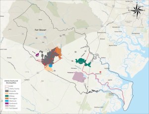
Municipalities within Liberty County.
Considering the increasing frequency and intensity of precipitation, the study highlights evolving risks to help policymakers and stakeholders plan effectively for climate impacts. The overarching goal of this report is to support the County’s capacity to navigate urban growth and flood risk uncertainties, fostering a resilient and adaptive community.
This study also analyzes flood vulnerabilities within Liberty County’s three Community Disaster Resilience Zones (CDRZ) since they represent opportunities for integrating resilience planning into broader community development efforts. Addressing flood risks within CDRZ ensures that these areas remain viable for growth and investment while also aligning with state and federal priorities for resilience funding.
Key Findings
Flood Risks
- Liberty County faces increasing flood threats due to sea level rise and more intense rainfall.
- Coastal areas and low-lying inland zones are especially vulnerable, particularly during tropical storms and hurricanes.
Building Damage
- Around 91% of buildings would not be damaged or would experience only minor issues (like damp walls or water stains).
- About 9% of buildings could suffer moderate damage.
- Less than 1% (only 82 buildings) are at high risk of severe or complete damage, mostly in areas like Halfmoon Landing and CDRZ #4 (Community Disaster Resilience Zone).
- Critical areas face flood depths ranging from 5 to 14 feet, prompting recommendations like elevating homes or restricting new development.
Displacement of Residents
- Approximately 1,550 households (about 6%) could be forced to temporarily relocate after a major flooding event.
- Lower-income and minority communities are more likely to be impacted.
Economic Impact
- Local industries such as hospitality, retail, health care, and commercial services are at risk.
- In a moderate flooding event:
- Property damage could cost $74 million.
- In a more widespread, less severe flood, damages could rise to $1.6 billion, with substantial losses in high-value homes and services.
- High-income households could see a 4–6% drop in real income, while lower-income households would be less affected.
- Employment losses would mainly affect sectors with a lot of frontline and service jobs.
Planning and Community Efforts
Liberty County has already started preparing:
- A hazard mitigation plan to reduce risks from flooding and storms.
- A long-term comprehensive plan (to 2040) that supports smart development and land use.
- Flood ordinances that require buildings in flood-prone areas to be elevated.
However, the report notes that some at-risk areas lie outside official FEMA flood zones, so current regulations may not cover all dangers.
Recommendations
To make Liberty County more resilient, the report recommends:
- Update building codes to reflect new flood risk data and climate forecasts.
- Retrofit buildings in high-risk areas, especially in places like Halfmoon Landing.
- Discourage new development in areas where floodwaters could reach 6 feet or more.
- Upgrade drainage systems and maintain infrastructure like culverts and creeks.
- Use green infrastructure, such as larger retention ponds and erosion-control landscaping.
- Plan for nature-based solutions to reduce flood impact along rivers and coastlines.
- Apply for funding from federal and state programs like FEMA’s BRIC, HMGP, and USDA grants.
Special focus should be given to the county’s four designated Community Disaster Resilience Zones (CDRZs), as they are eligible for additional funding and support.
UNDERSTANDING FLOOD SCENARIOS: A ROADMAP TO RESILIENCE, GOOSE CREEK, SC.
PR-2025-003-GooseCreek
This study presents a comprehensive flood resilience analysis for Goose Creek, South Carolina, to inform policy decisions and guide resilience
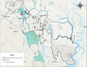
Goose Creek, South Carolina. Source: Source: FEMA, Esri | Charleston County GIS
planning strategies. The analysis evaluates future flood hazard scenarios, identifying areas within the community vulnerable to current and mid-century flooding. Considering the increasing frequency and intensity of precipitation, the study highlights evolving risks to help policymakers and stakeholders plan effectively for climate impacts. The overarching goal of this report is to support the City’s capacity to navigate urban growth and flood risk uncertainties, fostering a resilient and adaptive community.
This study also analyzes flood vulnerabilities within Goose Creek’s Community Disaster Resilience Zone (CDRZ) since it represents opportunities for integrating resilience planning into broader community development efforts. Addressing flood risks within CDRZ ensures that areas remain viable for growth and investment while aligning with state and federal priorities for resilience funding.
Key Findings
Flood Risks Are Rising
- Goose Creek is growing quickly and lies near rivers and wetlands, making it vulnerable to flooding.
- Climate change is bringing more frequent and stronger storms, increasing the chance of both coastal and inland (rain-related) flooding.
- About 31% of the city falls within FEMA-designated flood zones.
Building Damage Predictions
- 95% of buildings are expected to have no or only slight flood damage.
- About 5% (2,317 buildings) may experience moderate damage (like waterlogged floors and walls).
- Only 2 buildings are predicted to suffer severe damage.
- Moderate damage is most likely in neighborhoods like Wood Hill, Okatie, and Cane Bay.
- Many at-risk buildings are outside FEMA flood zones, meaning current regulations might not protect them.
People May Be Displaced
- Some residents may have to temporarily relocate after a flood, especially in lower-income or vulnerable areas.
- The report uses new modeling tools to estimate which households might be affected, combining social and housing data for better planning.
What the City Is Already Doing
- Goose Creek has added a Resilience Chapter to its city planning documents.
- It participates in Berkeley County’s Hazard Mitigation Plan.
- Local laws require certain buildings in flood zones to be elevated and flood-resistant.
Recommended Next Steps
The report provides many specific actions for different types of neighborhoods and zoning areas. Overall, it recommends:
- Avoid building in areas where floodwaters may reach 6 feet or more.
- Use new flood data to improve building codes and planning rules.
- Retrofit buildings with flood-proofing materials and elevated utilities.
- Install green infrastructure like rain gardens, bioswales, and retention ponds.
- Create overlay zones to apply stricter flood rules in areas at risk even if not officially labeled as flood zones.
- Educate residents and businesses about flood risks and encourage flood insurance.
- Apply for state and federal funding, especially in designated Community Disaster Resilience Zones (CDRZ), which get priority for grants.
Funding Opportunities
The city can apply for grants and loans from programs such as:
- FEMA’s BRIC, FMA, and HMGP
- HUD’s Community Development Block Grants
- South Carolina’s Resilience Revolving Fund
- USDA and EPA environmental programs
- Federal funds from the Bipartisan Infrastructure Law and Inflation Reduction Act
UNDERSTANDING FLOOD SCENARIOS: A ROADMAP TO RESILIENCE, HOMESTEAD, FL.
PR-2025-004-Homestead
This study provides a comprehensive flood resilience analysis for Homestead, assessing vulnerabilities to future flooding. It evaluates hazard scenarios to identify areas at risk from current and mid-century flooding, considering precipitation’s increasing frequency and intensity.

Homestead, Florida
By highlighting evolving risks, the study equips policymakers and stakeholders with data-driven insights to inform resilience planning, support urban growth, and enhance flood mitigation efforts. The overarching goal is strengthening the county’s capacity to navigate flood risk uncertainties while leveraging data for informed decision-making and grant opportunities.
Key Findings
Flood Risk Is High and Worsening
- Homestead’s location between the Everglades and Biscayne Bay makes it very prone to flooding from storms, heavy rain, and rising seas.
- Climate change will likely make floods more frequent and severe, especially in low-lying neighborhoods.
Building Damage Predictions
- About 49% of buildings are expected to have moderate damage in a realistic mid-century flood.
- 101 buildings could face severe damage, and 19 buildings could be completely destroyed.
- Many high-risk areas lie in or near FEMA’s Zone AH, but the study finds actual flood depths in these areas could be much higher than FEMA predicts.
- Some moderate-risk areas are outside FEMA flood zones, so existing rules may not protect them.
People May Be Forced to Relocate
- The study uses data about both buildings and people to estimate how many households might need to temporarily move.
- Residents in neighborhoods east of South Homestead Blvd. and near the Turnpike are especially vulnerable.
- Low-income and minority populations could be disproportionately affected.
What the City Is Already Doing
- Pump Station 22 is being upgraded to better manage wastewater during floods.
- Homestead participates in FEMA’s Community Rating System (CRS) and has achieved Class 7, saving residents money on flood insurance.
- The city has developed a variety of planning documents—economic development plans, neighborhood master plans, park plans, and comprehensive land-use plans—which can incorporate flood resilience strategies.
What’s Missing or Needs Improvement
- Many local plans don’t specifically address flooding, or they only cover areas identified in outdated FEMA maps.
- New climate-based data reveals vulnerabilities in additional areas not currently covered by local flood policies.
- More green infrastructure (like wetlands, bioswales, and permeable pavements) is needed to manage stormwater naturally.
Recommendations for Action
The report suggests that Homestead should:
- Update zoning rules to include areas identified as flood-prone in this report, not just those in FEMA maps.
- Retrofit high-risk buildings, raising them above expected flood levels and requiring flood-resistant materials.
- Improve drainage and stormwater systems, especially in areas with deeper expected floodwaters.
- Use nature-based solutions like wetlands and rain gardens to absorb excess water.
- Strengthen building codes to include elevated electrical systems and other resilient designs.
- Educate the public with checklists and clear information about flood risks and how to prepare.
Available Funding
Homestead can apply for state and federal grants to support these actions, including:
- FEMA programs (HMGP, BRIC, FMA)
- HUD disaster recovery grants
- NOAA coastal resilience funds
- Florida’s Resilient Florida Program and Rebuild Florida Program
- Infrastructure grants from the Bipartisan Infrastructure Law and Inflation Reduction Act
UNDERSTANDING FLOOD SCENARIOS: A ROADMAP TO RESILIENCE, FELLSMERE, FL.
PR-2025-005-Fellsmere-FL
This study presents a comprehensive flood resilience analysis for Fellsmere, FL, to inform policy decisions and guide resilience planning strategies. The analysis evaluates future flood hazard scenarios, identifying areas within the community vulnerable to current and mid-century flooding. The analysis was conducted using the IN-CORE platform (www.in-core.org), incorporating its Flood Damage Analysis and Population Dislocation Models. To account for midcentury climate conditions, flood data from Collective Water, the City stormwater consultant, was integrated, providing a comprehensive assessment of climate projections and future risks.

Fellsmere, FL
Key Findings
Flood Risks Are Low for Buildings
- Fellsmere is located in a low-lying, rural area of Indian River County and is prone to flooding from heavy rains and hurricanes.
- However, the report finds no buildings in the city are currently at risk of moderate, severe, or complete flood damage, even when using future climate projections.
- All buildings fall into the “no or slight damage” category, which means flood impacts are minimal or cosmetic.
No Expected Displacement
- Because buildings aren’t at risk, the analysis also finds no expected displacement of people from their homes due to flooding.
What the City Is Doing
Fellsmere is actively planning for resilience and has several strong initiatives already in place:
- Watershed Master Plan and Vulnerability Assessment (2024)
- Identifies vulnerable roadways and infrastructure under current and future climate conditions.
- Recommends stronger stormwater systems, better wetland protection, and public education.
- Calls for regulatory updates and potential funding through a stormwater utility.
- Economic Development and Resiliency Plan (2022)
- While not focused on flooding, it includes infrastructure upgrades like better roads and sewers that support flood resilience.
- Indian River County Mitigation Strategy (2020)
- Identifies flood as a major hazard and recommends regional stormwater projects and wetland conservation to manage risks.
- Comprehensive Plan (2018)
- Supports sustainable development with strong stormwater management, wetland protection, and low-impact development strategies.
- Encourages green infrastructure like open spaces and permeable surfaces to absorb rainwater.
Recommendations
Although no urgent actions are needed due to the low risk of damage, Fellsmere can continue strengthening its flood resilience by:
- Maintaining existing stormwater systems and upgrading as needed.
- Preserving wetlands and natural flood buffers.
- Using green infrastructure like rain gardens and permeable pavements.
- Working with regional partners on shared flood risks.
- Educating residents about flood risks and insurance, even if current risk is low.
Funding Opportunities
The report lists many federal and state funding options the city can use for stormwater, infrastructure, and resilience projects, including:
- FEMA (BRIC, FMA, HMGP)
- USDA, EPA, and HUD programs
- Florida Resilient Florida Program, Florida Forever, and Rebuild Florida
- Bipartisan Infrastructure Law and Inflation Reduction Act funds